


27.02.2016.JUGON.Tracé virtuel 1...

babeth35
User
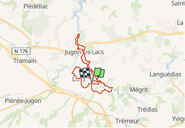

Length
29 km

Max alt
83 m

Uphill gradient
479 m
Km-Effort
36 km

Min alt
23 m

Downhill gradient
482 m
Boucle
Yes
Creation date :
2016-03-09 00:00:00.0
Updated on :
2020-07-20 15:38:07.842
7h34
Difficulty : Unknown

FREE GPS app for hiking
 SityTrail
IGN / Geographical institutes
SityTrail Plus
The world is yours!
About
Trail Walking of 29 km to be discovered at Brittany, Côtes-d'Armor, Jugon-les-Lacs Commune nouvelle. This trail is proposed by babeth35.
Positioning
Country:
France
Region :
Brittany
Department/Province :
Côtes-d'Armor
Municipality :
Jugon-les-Lacs Commune nouvelle
Location:
Unknown
Start:(Dec)
Start:(UTM)
551025 ; 5358770 (30U) N.
Comments